The Palmetto Trail’s Peach Country Passage from Landrum to Inman
Published 10:00 pm Monday, May 23, 2016
I often walk in Brookwood Park and I’ve been curious about a sign there. It tells about the Palmetto Trail. I read about it on the internet at palmettoconservation.org.
The trail is one of 16 cross-state trails in the U.S. and is 500 miles long. There are several passages and here in Landrum we are lucky enough to be part of the Peach Country Passage, a 14.1-mile section from Landrum to Inman.
Trending
It’s a quiet Sunday afternoon. I’m not a biker and a walk of 14.1 miles is a little out of my league. Using the amazing camera on my phone, I photograph the map on the sign. It shows the trail following along the road so I decide a Sunday drive is in order.
Remember the Sunday drive? Families would pile into the one car that the family owned and take a peaceful drive together, wandering through the countryside? Oh, the good ol’ days!
The starting point for my drive is Brookwood Park heading to Redlands Road. Markers along the route stating “Palmetto Trail” show the way. Shaded by trees, the road travels by farms as it leaves Landrum and takes a short jag on Route 11. Then it quickly takes a turn at Monroe Bruce Farm Road. Here the lane narrows down, with very little traffic passing by.
I notice the peach orchards that give the passage its name, Peach Country Passage, and imagine how beautiful a spring bike ride would be when the trees are in bloom.
Before long, I notice a cemetery. I always enjoy exploring country cemeteries, so I park along the roadside. An old wrought iron fence and gate catch my eye.
I notice a few stones have confederate flags placed next to them so I assume these were men who fought in the war. The dates on the stones bear this out. Under a graceful shade tree is a large marker with the name Mabry. I feel a sense of history as I continue to stroll through the grass and read names and dates.
Trending
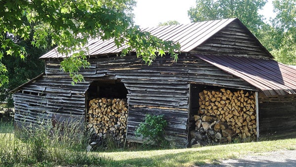
But it’s time to move along and see what else I discover. Next is a right turn onto Alverson Rd. The route meanders past some horse farms, peach orchards, and shady paths. I notice a small rustic barn stacked full of a winter’s supply of wood.
I make a quick stop to snap a photo.
As I merge onto Big Mulberry Trace, I come to Gramling and the first Palmetto Trail parking area. If I were bicycling, it would be time for a rest stop, a snack and a drink before moving along on Blue Ridge Street, next to the old railroad tracks.
I need to watch for a trail marker and a sharp left at Cothran Road. The view in the distance includes the shadowy outline of the Blue Ridge Mountains. The next marker takes me left to Windmill Hill Road. My map is showing me another turn that takes me over to Howard Gap Road. The markers seem to have disappeared and I’m lost between Littlefield and Howard Gap.
I decide to turn around and when I do, I luckily notice a couple of familiar faces sitting on a front porch. Ah, friends; maybe they can get me back on track. I wave out the window as they greet me and ask where I’m going.
“Well, I’m following the Palmetto Trail, but now I’m lost,” I explain. They give me some directions and I proceed on my way.
I arrive in Inman and locate the other end of the Peach Country Passage. As I drive into town, I notice an old Rexall drug store with a big sign painted on the window, advertising their old time soda fountain.
Since this is Sunday it’s closed but a bike ride scenario crosses my mind. Bicyclists could begin a ride in Landrum, first visiting Southern Delights or Stone Soup for breakfast. Upon reaching Inman, what could be more fun than a stop at the drugstore soda fountain for a malt or ice cream cone?
Heading back to Landrum I make a change to the route that is shown on my map. As I head down N. Howard St. out of town it becomes Compton Bridge Road. Watch for Windmill Hill Road and follow it. It will connect to Cothran Road, cutting out the confusing Howard Gap section and you won’t have to rely on my friends to show you the way.
Happy travels!


