Landslide maps available
Published 9:20 pm Sunday, February 14, 2021
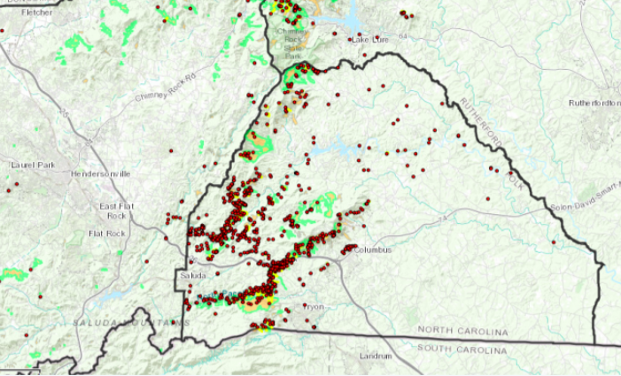
- People can now view where Polk County’s landslides have been over the years on maps recently created. (Map submitted by Polk County Government)
|
Getting your Trinity Audio player ready...
|
Polk County’s 265 landslides are now included on a map
POLK COUNTY—People can now see where Polk County’s 265 landslides have been over the years thanks to recent maps created.
The Polk County Board of Commissioners hears from Rick Wooten with the geological survey recently, who completed a study of the county’s landslides.
Many of the county’s landslides occurred during a May 2018 heavy rain event, when one person died during a mudslide along U.S. 176 in Tryon and a few days later 2 other people died when a tree fell and hit their vehicle. There was also a lot of property damage during the rain event in 2018, where many property owners lost and had damage to their homes and had major damage to their properties.
Maps have now been developed showing the landslide hazards in Polk and other western North Carolina counties and are available online.
The Landslide Hazards Map, which includes a tab for Polk County, is at https://unca.maps.arcgis.com/apps/MapSeries/index.html?appid=48bf3ffa7d914f6d9b4562db4afb5e80. The map also can be accessed through a link on the GIS (Geographic Information System) page at PolkNC.org.
The N.C. Geological Survey with the N.C. Department of Environmental Quality and the Division of Energy, Mineral and Land Resources is tasked with tracking such movements, according to Polk officials. The agencies published the Landslide Hazards in WNC maps online for those interested in this data for planning, land purchases, construction and other considerations.
Questions about the Landslide Hazards in WNC maps should be directed to Senior Geologist Wooten with the Division of Energy, Mineral, and Land Resources-Geological Survey at rick.wooten@ncdenr.gov.


-
Polls
 Loading ...
-
-