Weather service forecasts more rain to pelt area this week
Published 11:52 am Monday, May 21, 2018
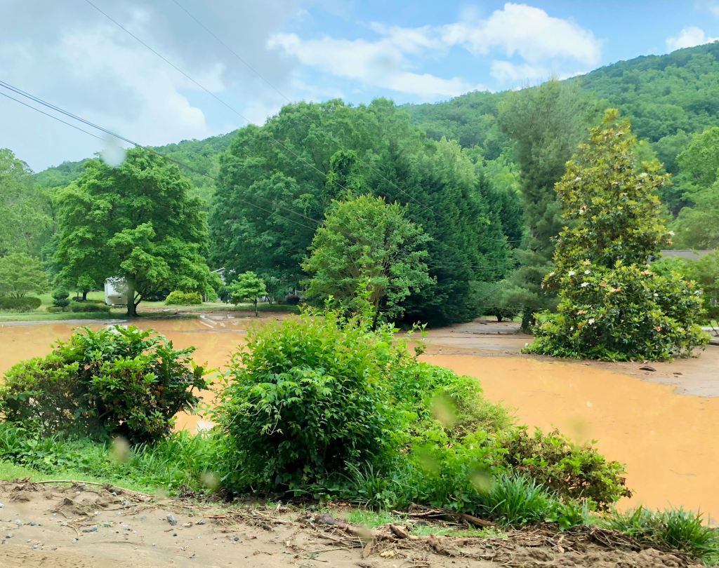
- A stretch of property along U.S. 176 toward Saluda that was impacted by the flooding and mudslides that occurred due to the series of powerful rainstorms that pelted Polk County Friday. (Photo by Ted Yoakum/Tryon Daily Bulletin)
POLK COUNTY — While many in Polk County continue to reel from the impact of the flooding and mudslides that occurred following the massive series of rainstorms that pelted the region Friday, officials with the National Weather Service are warning that more rain is expected to roll into the area this week.
The weather agency is forecasting chances of showers and thunderstorms through Sunday, with a 30 percent chance of rain Monday, which could bring up to 1/10 of an inch of rain, and 70 percent chance of rain on Tuesday, which could bring between a quarter to half an inch of precipitation. Meteorologists also forecast:
- Wednesday, 50 percent chance of showers and thunderstorms
- Thursday, 30 percent chance of showers and thunderstorms
- Friday, 40 percent chance of showers and thunderstorms
- Saturday, 60 percent chance of showers and thunderstorms
- Sunday, 70 percent chance of showers and thunderstorms
While the rainfall is expected to be smaller than Friday’s downpour — which meteorologists estimate brought between 4 to 8 inches of rain to western Polk County, and between 8 to 10 inches in parts of Saluda — with the water levels of many local rivers still elevated and the soil still soaked, the dangers of flash flooding remain a concern, said Jake Wimberley, a meteorologistwith the NWS Greenville-Spartanburg forecast office.
“In general, this week will not be good for recovery, just because conditions will likely remain wet,” Wimberley said. “I would tell people to be prepared in case something happens again. I can’t say particularly which areas will get it the worst, but any heavy rain will make flooding more likely.”
The storms are forecasted to occur just days after a series of heavy rain showers pelted Polk County and other parts of the region Friday, which resulted in flooding and mudslides — the latter of which claimed the life of a woman. Residents living along U.S. 176 between Tryon and Saluda and the surrounding area were most devastated, with the impacted portion of the highway remaining closed to through traffic and observers while road crews cleanup the mud, boulders and debris that has fallen on the roadway due to the storm, as well as repair the damaged shoulders, culverts, guardrails and other fixtures.
The heavy rainfall also closed a portion of Interstate 26 for six hours on Friday evening and Saturday morning due to flooding and downed trees, with department of transportation crews reopening the roadway early Saturday.
While other portions of western North Carolina and upstate South Carolina received heavy rain on Friday, Polk County received the brunt of the storms that developed in the region — two weather stations east of Saluda reported rainfall of 8.24 and 9.83 inches, respectively, Wimberley said. While storms are common in the Blue Ridge Escarpment area on the North Carolina/South Carolina border, where moisture from the Atlantic Ocean often becomes rain due to the rise in elevation, the conditions on Friday created a powerful series of rainstorms that pelted the region for several hours, Wimberleysaid.
“The winds were blowing in such a way that, as one storm moved away, another moved into its place,” he said. “The terrain helped keep the storms in place as well. …Everything came together in the right way so the storms kept developing, over and over again.”
With the ground already soaked with between 3 to 5 inches of precipitation in the days leading up to Friday’s storms, the additional precipitation caused the dirt leading up to Saluda to become dislodged, leading to the mudslides that were responsible for damaging homes and roadways in the area, Wimberleysaid.
The storms appear to be among the worst in the region’s history.
In November 1977, the Pacolet valley experienced a flood, which resulted in the death of a young child who was swept from his father’s arms. In the summer of 1916, U.S. 176 leading to Saluda was also rendered impassible due to rainfall, according to the Melrose Historic District Facebook page.
With more rain on the way, and without much time for accumulated water to settle beneath the soil, there is still danger that additional mudslides could occur, the meteorologist added.
The NWS asks that residents remain informed on weather forecasts, and check with the department of transportation for road closing information during severe rainfall and other weather conditions. The NWS advises those driving during heavy rain to avoid traveling on flooded roadways.
For forecasts and emergency weather warnings, people may visit www.weather.gov.


-
Polls
 Loading ...
-
-